Select or drop a image or 3D model here to search.
We support JPG, JPEG, PNG, GIF, WEBP, GLB, OBJ, STL, FBX. More formats will be added in the future.
Asset Overview
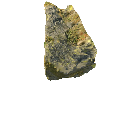
[Text Source](http://webgis.archaeology.ie/historicenvironment/?SMRS=KE037-022) An irregularly-shaped boulder formerly lay on the strand at the base of the low cliffs that border the S side of Tralee Bay. It is very likely that the stone may have fallen to this position from the land above due to erosion of this area by the sea. . The upper surface is divided roughly in two, along its E-W axis, by a combination of a natural ridge and a pocked line. Above this to S are about 36 cup-marks varying in diameter from 0.02 to 0.09m. At the W edge of this concentration are 2 parallel oval cups and a third less well-defined sub-oval depression. On the N portion of the stone the motifs are less densely distributed. They consist of at least 9 cup-marks and 2 parallel oval depressions from one of which a long groove extends W for 0.32m. The stone was moved to its present location in October 1997


/Screenshots/ground.webp)
/Screenshots/ground.webp)


/Screenshots/ground.webp)


/Screenshots/ground.webp)

/Screenshots/ground.webp)