Select or drop a image or 3D model here to search.
We support JPG, JPEG, PNG, GIF, WEBP, GLB, OBJ, STL, FBX. More formats will be added in the future.
Asset Overview
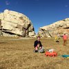
One of the first maps completed using the Maps Made Easy Beta that utilizes Terrain Awareness compiled from NASA-databases. The UAV changes altitude as it cruises back and forth to get better coverage of all areas, not just the low ones.